Decoding France’s regional winds is an important part of understanding weather conditions in the summer.
Many of these weather phenomena have become more frequent or more intense due to climate change. Heatwaves for example, are occurring more often than ever before, arriving earlier in the year and lasting longer than they once did.
Here’s a guide to some of the weather phenomena you’re most likely to encounter in France.
Regional winds
The southern half of France is home to most of the country’s mountainous terrain, and it is there that regional winds are the most common.
Regional winds play a significant role in shaping the local climate, sometimes even going so far as to shape the landscape and regional crops.
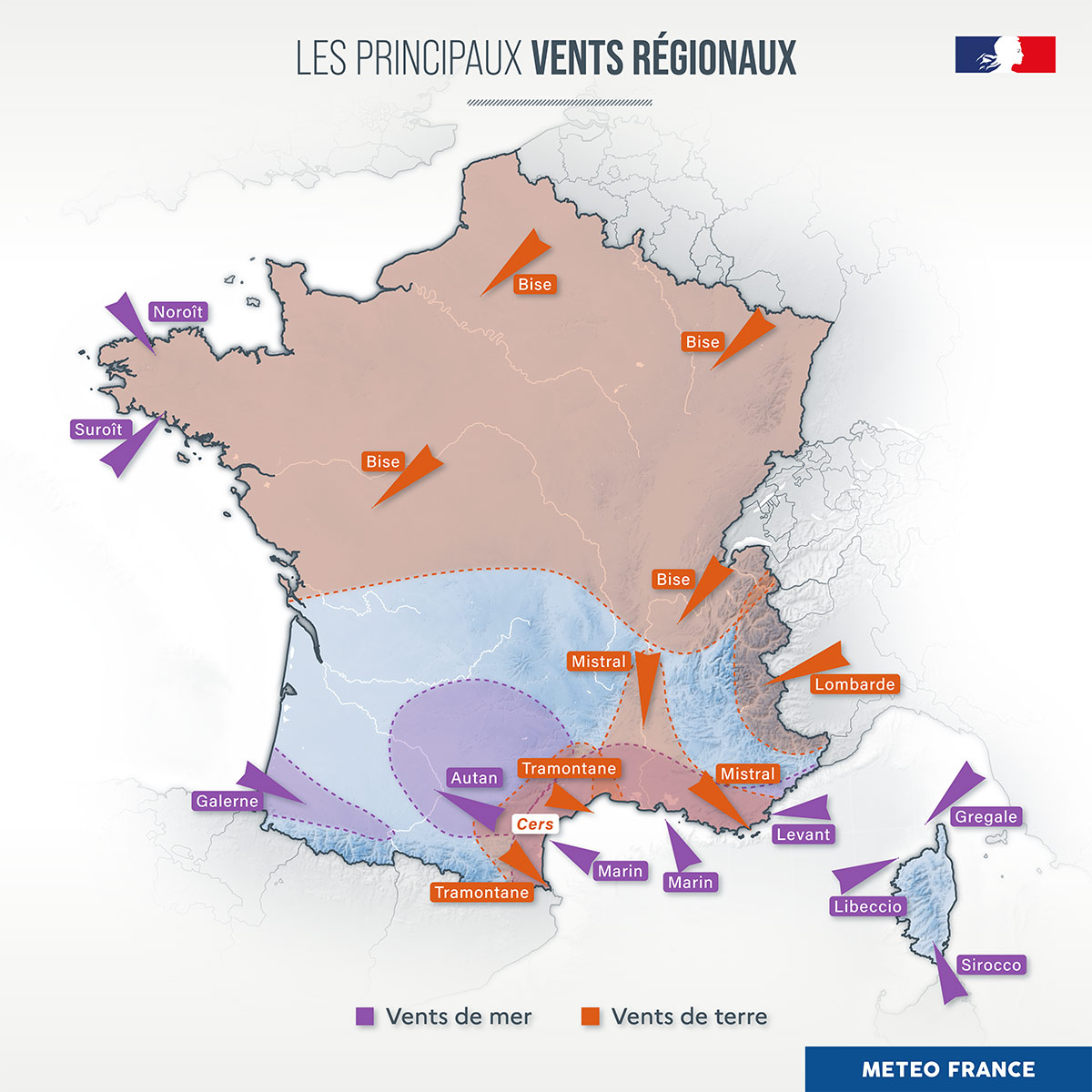 Regional winds map from forecaster Météo-France.
Mistral
One of France’s famous regional winds is the mistral. This is a strong, cold, dry wind that funnels down the Rhône Valley before sweeping across Provence and the Mediterranean coast.
Although it is most common outside the height of summer, it can blow at any time of year, often reaching gusts of 80 to 100 kilometres per hour or more.
The mistral strips moisture from vegetation, creating crystal-clear blue skies but also significantly increasing the risk of wildfires during hot, dry spells.
Tramontane
Often confused with the mistral, the tramontane is another powerful regional wind that affects southern France, particularly Occitanie and the Pyrénées-Orientales.
It blows from the northwest between the Pyrénées and the Massif Central before reaching the Mediterranean. Like the mistral, it is dry, can last for several days and contributes to elevated wildfire risk by rapidly drying vegetation.
Enbata
Visitors to the French Basque Country may hear locals refer to the enbata – that’s the term in the local Basque language, you might also hear it referred to in French as coup de galerne.
Unlike the mistral, the enbata is a local sea breeze that develops on hot summer afternoons as the land heats more quickly than the Atlantic Ocean.
It can strengthen rapidly during the afternoon, bringing sudden gusty winds along the coast that can catch anyone by surprise, often blowing up sudden sand storms. It is also accompanied by a rapid and sudden drop in temperatures.
Autan
Known locally as the “wind that drives people mad” because of its persistence, the autan affects the Toulouse region and parts of Tarn and Aude.
This warm, humid southeasterly wind often develops ahead of unsettled weather and can precede severe thunderstorms during summer.
Marin
Along the Mediterranean coast, another familiar summer wind is the marin.
Blowing in from the sea, it carries warm air inland. While it can make coastal areas feel particularly humid, it also provides the moisture needed for some of the heavy thunderstorms and torrential downpours that affect southern France.
Bise
The bise is a cold, dry wind that blows from the north or north-east across much of central and eastern France. Unlike winds such as the mistral or tramontane, it is not generally considered a distinctly regional phenomenon.
However, when the bise is funnelled between the Jura Mountains and the Alps, it becomes stronger and more consistent in both speed and direction. In these conditions, it is recognised as a regional wind affecting Switzerland, the Jura and the northern Alps.
If you’re confused about why it is called ‘bise‘ (kiss) when it doesn’t seem very friendly, the word itself comes from German, not French, because it often blows from the north-east along the German border.
Stay up to date on all regional winds with French forecaster Météo-France.
Now we’ve got all of the specific regional winds out of the way, here’s a look at home of the other weather you might experience during a French summer.
Violent summer thunderstorms
Hot afternoons frequently end with intense thunderstorms, particularly over central and eastern France and near mountain ranges.
While these storms are a normal feature of summer, warmer air is capable of holding more moisture, increasing the potential for intense rainfall. Some storms produce damaging winds, torrential rain and large hailstones capable of causing widespread damage to vineyards, crops and vehicles.
France is considered one of Europe’s hail hotspots, with some recent storms producing hailstones larger than tennis balls.
During prolonged hot, dry periods, some storms generate lightning while producing little rain at ground level. These so-called dry thunderstorms have become a growing concern because lightning strikes can ignite wildfires in drought-stricken forests and grasslands.
Flash floods and Mediterranean downpours
Late summer can also bring episodes of exceptionally heavy rainfall to southern France.
Warm Mediterranean waters provide abundant moisture which, when lifted over the Cévennes mountains or other elevated terrain, can produce torrential rain within just a few hours. These so-called épisodes méditerranéens or épisodes cévenols are capable of causing dangerous flash flooding even after prolonged periods of drought.
Saharan dust
Another increasingly familiar summer sight is the arrival of Saharan dust, or in French sable du Sahara.
Strong southerly airflows can carry fine mineral dust thousands of kilometres from North Africa into France, turning the sky hazy or orange and, when mixed with rain, leaving a layer of reddish-brown dust on cars and buildings.